Log in
All resources
Create a design
385 Free Images of 1700 Maps
bibliothèque nationale de france
maps by pieter mortier
maps by alexis-hubert jaillot
eran laor cartographic collection
robert cordier (engraver)
1700s maps of slovenia
french-language maps
lawrence h. slaughter collection of english maps, charts, globes, books and atlases
1700s maps of north rhine-westphalia
1700s maps of hesse
maps of paris from bibliothèque nationale de france
maps of paris by alexis-hubert jaillot
mappe-monde by guillaume delisle (18th century)
french-language maps of the world
maps of paris from bibliothèque nationale de france
maps of paris by alexis-hubert jaillot
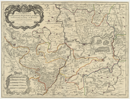
map of the circle of the rhineland by sanson
1700s maps of rhineland-palatinate
maps by pieter mortier
1700 maps of africa
map of the circle of austria by sanson
1700s maps of austria
maps of alsace by guillaume sanson
maps by alexis-hubert jaillot
british library - off the map alice collection - gardens
british library maps collections
old maps of narva
1700 maps
maps by willem and johannes blaeu
history of kotlas
map of the upper rhenian circle by sanson
maps by nicolas sanson
map of the circle of the rhineland by sanson
1700s maps of rhineland-palatinate
1700s maps of the world
le neptune francois
old maps of the amazon river
1700s maps of brazil
map of ghent by foppens
french-language maps of the world
1700s maps of the world
maps by pieter mortier
old maps of asia
map of ghent by harrewijn
jacobus harrewijn
map of italy by guillaume delisle (1700)
1700s maps of italy
topographia austriacarum (merian)
baroque
map of italy by guillaume delisle (1700)
eran laor cartographic collection
map of europe by guillaume delisle (1700)
1789 maps of europe
maps by alain manesson-mallet
history of galle fort
print room of the university of antwerp
plattegrond van antwerpen
maps by alexis-hubert jaillot
maps by nicolas sanson
map of the circle of austria by sanson
1700s maps of austria
maps of brest, france by antoine aveline
brest (france) in the 1700s
le neptune francois
1700 maps of cuba
17th-century celestial maps
bodleian maps collection
18th-century maps of the dardanelles
1700s maps of turkey
17th-century celestial maps
bodleian maps collection
18th-century maps of veneto
1700s maps of slovenia
maps of paris in the 1700s
1700s maps of paris
maps by abraham ortelius
maps by petrus schenk
lawrence h. slaughter collection of english maps, charts, globes, books and atlases
1700s maps of north america
biblioteca di storia e cultura del piemonte "giuseppe grosso"
1700s maps of liguria
maps of alsace by guillaume sanson
1700s maps of alsace
map of the upper rhenian circle by sanson
1700s maps of north rhine-westphalia
1700s maps of the holy roman empire
maps by joachim bormeester
eran laor cartographic collection
pierre aveline
maps in the library of congress
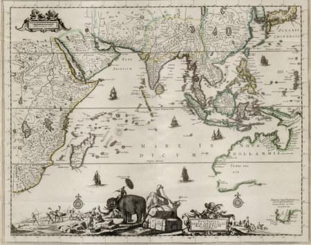
18th-century maps of sumatra
map of amsterdam by julius milheuser after daniël stalpaert, 1662
julius milheuser
18th-century maps of veneto
1700s maps of slovenia
maps of paris from bibliothèque nationale de france
plan de roussel
map of the circle of austria by sanson
1700s maps of austria
lucas achtschellinck
baroque
map of the circle of austria by sanson
1700s maps of austria
maps of the iberian peninsula by guillaume delisle
1700s maps of the iberian peninsula
maps of paris from the david rumsey historical map collection
map of paris by jouvin de rochefort (boutier 133)
lawrence h. slaughter collection of english maps, charts, globes, books and atlases
nypl lionel pincus and princess firyal map division
old maps of the republic of genoa
maps by alexis-hubert jaillot
old maps of the republic of genoa
maps by alexis-hubert jaillot
bibliothèque nationale de france
sanson map of lorraine
eran laor cartographic collection
sanson maps of asia
map of the circle of austria by sanson
1700s maps of austria
bibliothèque nationale de france
sanson map of lorraine
bibliothèque nationale de france
sanson map of lorraine
map of the upper rhenian circle by sanson
1700s maps of north rhine-westphalia
eran laor cartographic collection
pierre aveline
maps in the library of congress
1769 maps of europe
details of old maps
michael burghers
18th-century maps of veneto
1700s maps of slovenia
maps of the iberian peninsula by guillaume delisle
1700s maps of the iberian peninsula
sanson maps of the netherlands
robert cordier (engraver)
maps by pieter mortier
old maps of asia
maps of algiers by braun & hogenberg
maps of the iberian peninsula by guillaume delisle
1700s maps of the iberian peninsula
maps of the iberian peninsula by guillaume delisle
1700s maps of the iberian peninsula
lawrence h. slaughter collection of english maps, charts, globes, books and atlases
1700 maps of the atlantic ocean
lawrence h. slaughter collection of english maps, charts, globes, books and atlases
1700 maps of the atlantic ocean
maps from the earth and its inhabitants, vol. xii
africa in the 1890s
carte de l'amérique septentrionale by guillaume delisle (1700)
1700 maps of north america
eran laor cartographic collection
cornelis de bruyn
maps in the stadsarchief amsterdam
daniel stoopendaal
1700s maps of rhineland-palatinate
maps of vangiones by sanson
lawrence h. slaughter collection of english maps, charts, globes, books and atlases
nypl lionel pincus and princess firyal map division
maps by pieter mortier
maps from gallica
nicolaes visscher ii
maps from gallica
map of italy by guillaume delisle (1700)
bibliothèque nationale de france
eran laor cartographic collection
pierre mortier
eran laor cartographic collection
pierre mortier
map of italy by guillaume delisle (1700)
1700 maps of italy
1700s maps of the tsardom of russia
1700s maps of eastern europe
eran laor cartographic collection
cornelis de bruyn
eran laor cartographic collection
cornelis de bruyn
18th-century maps of corsica
maps by thomas kitchin
a new map of the island of tobago... - by tho.s kitchin... - btv1b53121990k
maps by thomas kitchin
maps by pieter mortier
maps from gallica
a new map of the island of tobago... - by tho.s kitchin... - btv1b53121990k
maps by thomas kitchin
broadsheet prints from koninklijke bibliotheek - maps
broadsheet prints from koninklijke bibliotheek
broadsheet prints from koninklijke bibliotheek - maps
broadsheet prints from koninklijke bibliotheek
antoine-françois tardieu
maps from gallica
broadsheet prints from koninklijke bibliotheek - maps
broadsheet prints from koninklijke bibliotheek
1700s maps of rhineland-palatinate
maps of east palatinate by sanson
maps of brest from bibliothèque nationale de france
brest (france) in the 1700s
lawrence h. slaughter collection of english maps, charts, globes, books and atlases
nypl lionel pincus and princess firyal map division
maps by alexis-hubert jaillot
old maps of duchy of cleves
mappe-monde by guillaume delisle (18th century)
1700s maps of the world
maps by pieter mortier
maps from gallica
18th-century maps of the indian ocean
18th-century maps of southeast asia
101 - 200 of 385
Next page
/ 4


![Map of Peru, Brazil, and Amazon - Guillaume de L'Isle, [1703-1708]](https://cdn.creazilla.com/illustrations/10000755782/map-of-peru-brazil-and-amazon-guillaume-de-lisle-1703-1708-md.jpg)


![[Southern celestial hemisphere], 1700](https://cdn.creazilla.com/illustrations/10000701462/southern-celestial-hemisphere-1700-md.jpg)

![[Northern celestial hemisphere], 1700](https://cdn.creazilla.com/illustrations/10000985046/northern-celestial-hemisphere-1700-md.jpg)


![Alsace divided into its main parts: namely the landgraviates of Upper and Lower Alsace and the Suntgaw / by Mr. Sanson, ...; Cordier sculpted; [cartouche] S[imonneau] f., 1700](https://cdn.creazilla.com/illustrations/10000469742/alsace-divided-into-its-main-parts-namely-the-landgraviates-of-upper-and-lower-alsace-and-the-suntgaw-by-mr-sanson-cordier-sculpted-cartouche-simonneau-f-1700-sm.webp)


![Map of Paris ([Reprod. in facsim.]) / by Roussel, engineer in 1700, 1730](https://cdn.creazilla.com/illustrations/10001522196/map-of-paris-reprod-in-facsim-by-roussel-engineer-in-1700-1730-md.jpg)


![North America: based on the observations of Mrs. de l'Académie Royale des Sciences & some others, & on the most recent memoirs, 1700 [i.e. 1708]](https://cdn.creazilla.com/illustrations/10001447935/north-america-based-on-the-observations-of-mrs-de-lacadmie-royale-des-sciences-some-others-on-the-most-recent-memoirs-1700-ie-1708-md.jpg)